Best Oregon Waterfalls to Hike to (Easy Stops + Bigger Hikes)
There’s something about waterfalls that makes otherwise reasonable people behave irrationally — myself included.
I’ve definitely done the “it’s only twenty minutes” lie. I’ve added one more stop to a day that was already full. I’ve stood in the rain because the flow was better “right now.” And honestly? I’ve never regretted it.
Oregon has 238 named waterfalls, and you could spend a lifetime chasing them. But if you’re planning a trip — or just want a guaranteed good stop — you don’t need all 238. You need the ones that are actually worth your time.
This guide organizes the waterfalls I’ve been to by region, with quick trail details, best timing, and simple pairing ideas so you can plan an efficient day, stack a few stops on a road trip, and walk away thinking, “Yep. That was worth it.”
The Columbia River Gorge has the highest concentration of waterfalls in the Pacific Northwest — dozens within a 30-minute radius. Because it deserves its own deep dive (including permits, crowd strategies, and day-trip loops), I’ve created a separate guide here: the best waterfall hikes in the Columbia River Gorge (Oregon + Washington)

Disclosure: This post may contain affiliate links. If you purchase through these links, I may earn a small commission at no extra cost to you. Thanks for supporting The Trekking Mama.
Quick Reference: Oregon Waterfalls at a Glance
- Best bang-for-your-buck (easy + big payoff): Salt Creek Falls, Toketee Falls, Watson Falls
- Best full-day waterfall hike: Silver Falls (Trail of Ten Falls)
- Best for photographers / dramatic setting: Abiqua Falls, Proxy Falls, Toketee Falls
- Best family-friendly short loops: Sahalie + Koosah Falls
- Best “wait until late season”: Ramona Falls (safer once the Sandy River drops)
When to Go: Spring Timing by Region
Spring is prime waterfall season, but timing varies by elevation and snowmelt:
March–April (Early Spring): Columbia River Gorge waterfalls peak with winter rain. Lower-elevation trails are accessible. Higher routes may still have snow. Best time for the Gorge — covered in my separate CRG waterfall guide.
April–May (Mid Spring): The sweet spot for most waterfalls on this list. High water flow, accessible trails, wildflowers starting. Silver Falls, Abiqua, Toketee, and Watson are all prime.
May–June (Late Spring): Higher-elevation passes opening. Salt Creek Falls has rhododendrons blooming around it. Sahalie and Koosah at peak color. Ramona Falls becomes accessible once the Sandy River drops.
June–July (Early Summer): Highway 242 opens (check TripCheck.com) — this is when Proxy Falls becomes reachable. Crowds increase across the board.
General rule: Visit 24–48 hours after heavy rain for maximum flow. Watch for slippery trails and bring waterproof layers.
What to Bring for Oregon Waterfall Hikes
Waterproof hiking boots — Oregon trails stay wet year-round. I wear the La Sportiva Bushido III for grip on wet rock and muddy trails.
Rain jacket — non-negotiable near waterfalls. I use the Aspire 3L Jacket — ultralight and always in my pack.
Trekking poles — essential on slippery trails like Abiqua and Ramona. I use Black Diamond Trail Ergo Cork.
Layers — canyon temps drop fast near the water. I always pack my REI Magma Down Hoodie.
Daypack — for longer loops like Silver Falls and Diamond Creek. I use the Osprey Tempest 20.
NW Forest Pass — required at Salt Creek, Diamond Creek, Drift Creek, Ramona, and Tumalo. Get it here or save with the America the Beautiful Pass which covers every national forest and national park.
Willamette Valley (Near Portland/Salem)
This is the easiest region in Oregon to build a full waterfall day without committing to long mileage or remote roads. Trails are well-marked, access is straightforward, and you can stack high-impact stops within an hour of each other.
Silver Falls State Park can fill an entire day if you hike the full Trail of Ten Falls loop. If you want something more rugged and dramatic, Abiqua Falls sits about 45 minutes away. Do Silver Falls in the morning and Abiqua in the afternoon for a balanced waterfall day — maintained trails first, rope scramble second.
Abiqua Falls – Santiam State Forest, OR
Silverton, OR · 0.8 mi RT · 200 ft gain · Moderate-Hard · Best in: March–May
No pass required · 4WD required for lower trailhead (We parked and walked the road down)
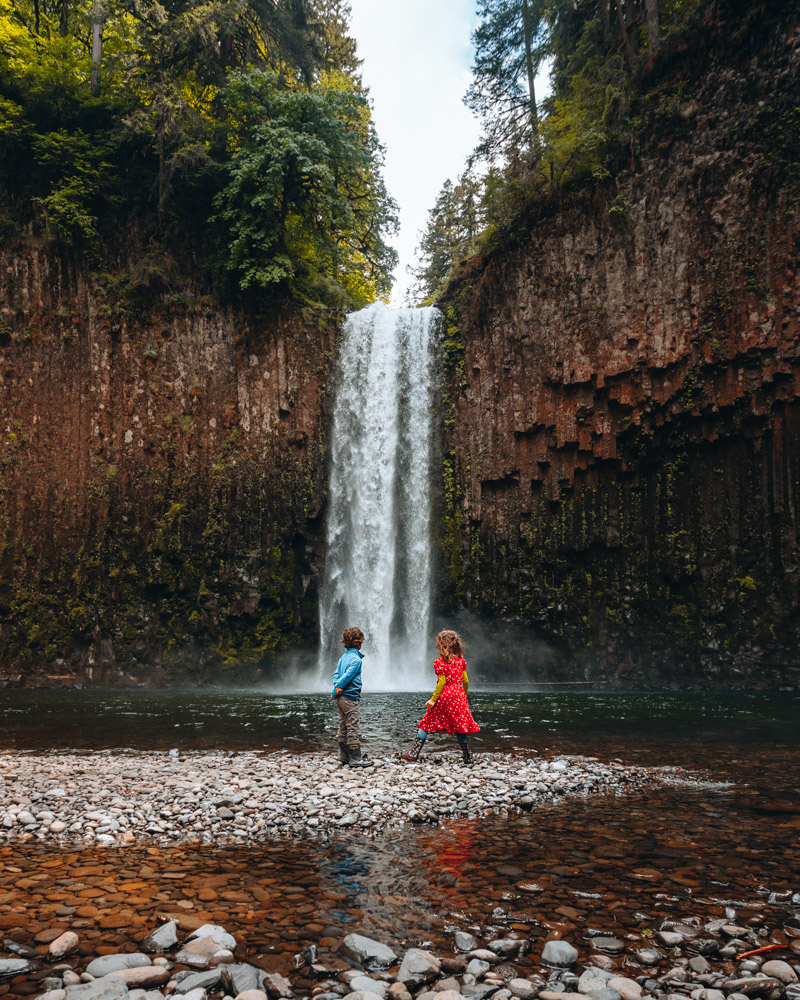
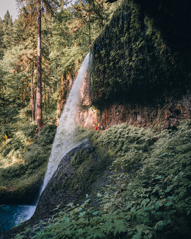
Abiqua Falls is one of the most striking waterfalls in Oregon — not because it’s the tallest or easiest, but because of where it sits. A deep basalt amphitheater, moss-covered walls, and an emerald pool at the base make the whole canyon feel secluded and cinematic.
The hike in is short but feels adventurous. A muddy descent through forest leads to a steep final stretch and a rope-assisted scramble down to the canyon floor. It’s the kind of approach that makes the reveal more satisfying — you hear the water first, then the canyon opens up around you.
Because of the muddy descent and rope scramble, Abiqua feels more adventurous than its short mileage suggests. If you’re comfortable with uneven footing and have dry road access, the payoff is dramatic — one of the most distinctive waterfall settings in Oregon.


Good to know: About 10 miles east of Silverton. No pass required. The road to the trailhead is unpaved and gets worse after rain — check recent trip reports before driving out. No facilities.
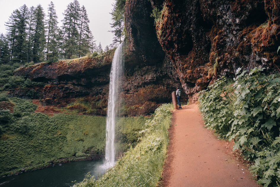
Silver Falls State Park – Trail of Ten Falls, OR
📍 Sublimity, OR · 7.2 mi loop · 800 ft gain · Easy-Moderate 🕐 Best: April–June (accessible year-round)
$5 state park day-use fee
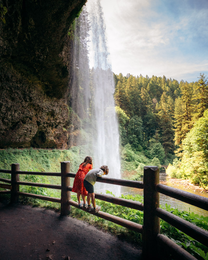
Silver Falls delivers more waterfall per mile than almost anywhere in Oregon — ten waterfalls on one well-maintained loop and several of them large enough to walk behind.
That’s what sets it apart. South Falls is the headliner: the trail curves directly behind the curtain of water, and you feel the mist before you step underneath it. North Falls offers a similar walk-behind experience but feels narrower and more enclosed, almost cave-like in sections.
At 7.2 miles for the full loop, this is a half- to full-day hike. If you’re short on time, use the cutoff trails and prioritize South and North Falls. Go early in spring — weekends fill quickly, and this is Oregon’s most popular state park for a reason.


Umpqua National Forest (Southern Oregon)
This stretch of OR-138 along the North Umpqua River is known as the “Highway of Waterfalls,” and it’s one of the easiest places in Oregon to string together multiple high-quality falls in a single day. Most hikes are short, parking is straightforward, and the waterfalls are spaced just minutes apart.
Toketee Falls and Watson Falls are only 15 minutes from each other and can be combined in 2–3 hours of total hiking. Add Umpqua Hot Springs for a post-hike soak.
Beyond Toketee and Watson, this corridor includes additional stops like Susan Creek Falls, Whitehorse Falls, Clearwater Falls, and Lemolo Falls — making it one of the most waterfall-dense stretches of highway in Oregon.
Toketee Falls – Umpqua National Forest, OR
📍 Idleyld Park, OR · 0.8 mi RT · 127 ft gain · Best: March–June
No pass required
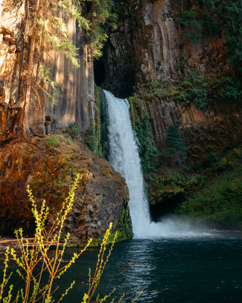
Toketee Falls is one of the most visually distinctive waterfalls in Oregon — two tiers spilling over perfectly formed columnar basalt, framed in a way that almost doesn’t look real.
The trail is short and straightforward, following the North Umpqua River before climbing a series of wooden staircases to a well-placed viewpoint. When the water is running strong in spring, the symmetry of the falls is what gets people — it feels deliberate, almost architectural.
There’s an unofficial scramble route to the base that some hikers take, but it’s steep and unmaintained. Most visitors stick to the viewpoint, and honestly, it delivers. This is an easy, high-impact stop that pairs naturally with Watson Falls just down the road.
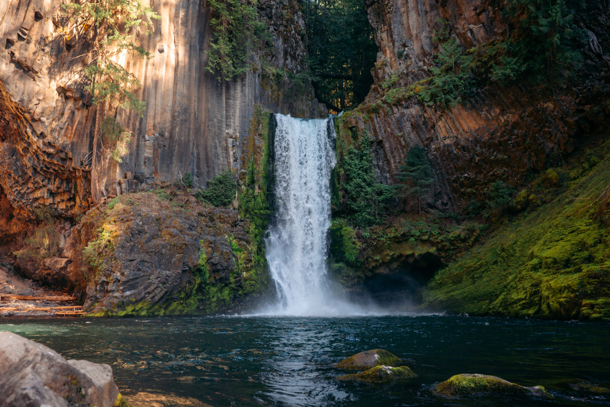
Good to know: Remote location — plan this as part of an Umpqua day trip, not a standalone drive. Pair with Watson Falls (15 minutes away).
Watson Falls – Umpqua National Forest, OR
📍 0.8 mi RT • 150 ft gain • Easy • No pass
Best time: March to June

Watson Falls is one of the tallest waterfalls in Oregon at 293 feet, and it’s surprisingly easy to miss because Toketee sits just down the road.
The hike is short and well-maintained, ending at the base where the scale becomes obvious. Standing beneath it, the drop feels enormous — a nearly uninterrupted wall of water falling through open forest. It doesn’t have Toketee’s symmetry, but the vertical presence is what makes it memorable.
Because the effort is minimal and the payoff is dramatic, this is an easy add-on when you’re already in the corridor. If you’re driving the Highway of Waterfalls, there’s little reason to skip it.
McKenzie River Corridor (Central Oregon)
This corridor offers some of the most photogenic waterfalls in Oregon, with several major stops within 20–30 minutes of each other. The terrain varies from roadside viewpoints to longer forested loops, making it easy to customize your day.
Salt Creek Falls and Diamond Creek Falls share a trailhead and pair naturally. Sahalie and Koosah Falls connect via a short loop along the river. Add Tamolitch (Blue Pool) to round out a half- to full-day outing. If Highway 242 is open, Proxy Falls becomes a seasonal highlight worth adding.
Best for: stacking variety without long drives. Base yourself in Bend, Sisters, or Eugene.
Salt Creek Falls – Willamette National Forest, OR
📍 Hwy 58, OR · 0.6 mi RT · 209 ft gain · Best: April–June
NW Forest Pass ($5) or $5 day use

Salt Creek Falls drops 286 feet in a single, uninterrupted plunge — the second tallest waterfall in Oregon and one of the easiest major waterfalls in the state to access.
The main viewpoint is just a short walk from the parking lot, making this one of the highest payoff stops relative to effort. Even from above, the scale is obvious — the volume of water moving in spring feels outsized for how little hiking it requires.
For a closer look, a steep trail descends toward the base, where the mist is heavy during peak flow. In late May and early June, rhododendrons bloom along the canyon rim, adding color to an already dramatic setting.
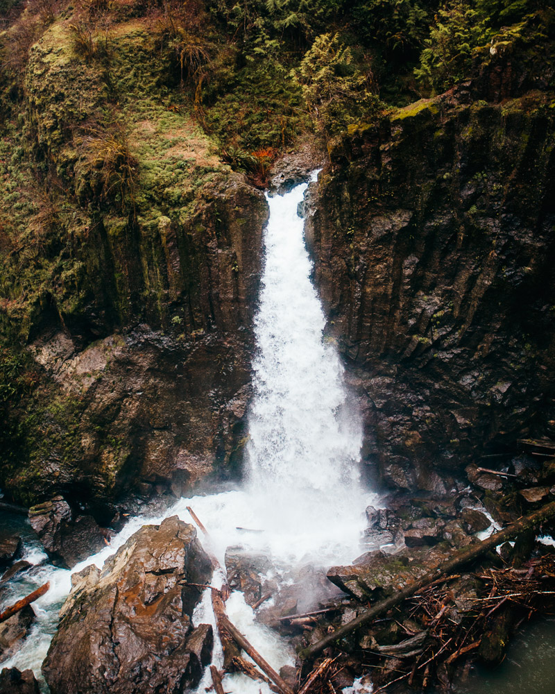
Diamond Creek Falls – Willamette National Forest, OR
📍 Hwy 58, OR · 4 mi loop · 741 ft gain · Best: May–July
NW Forest Pass ($5) or $5 day use

Diamond Creek Falls sits just steps from Salt Creek’s trailhead but sees a fraction of the traffic. Where Salt Creek delivers immediate scale, Diamond Creek offers a longer, quieter loop through forest before revealing a multi-tiered cascade spilling over moss-covered rock.
This feels more like a true hike than a viewpoint stop. The trail winds steadily before reaching the falls, and with the newer bridge in place, the loop is straightforward and well-defined. The cascade doesn’t hit you all at once — it reveals itself in layers as you move along the trail.
If you’re already at Salt Creek and have the time, adding Diamond Creek gives you contrast — towering plunge first, then a quieter, more textured waterfall that rewards a slower pace.
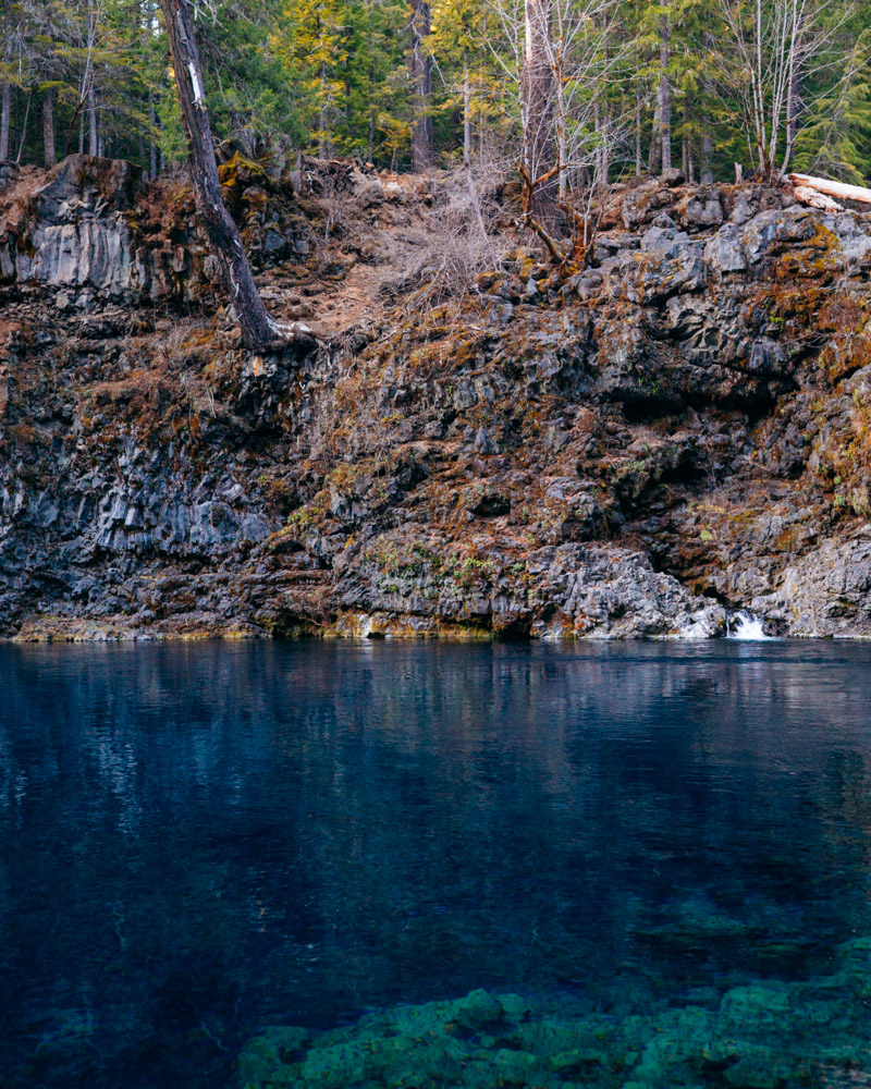
Tamolitch Falls (Blue Pool)
📍 McKenzie River Trail, OR · 4 mi RT · ~200 ft gain · Best: Year-round
No pass required
Best time: All year
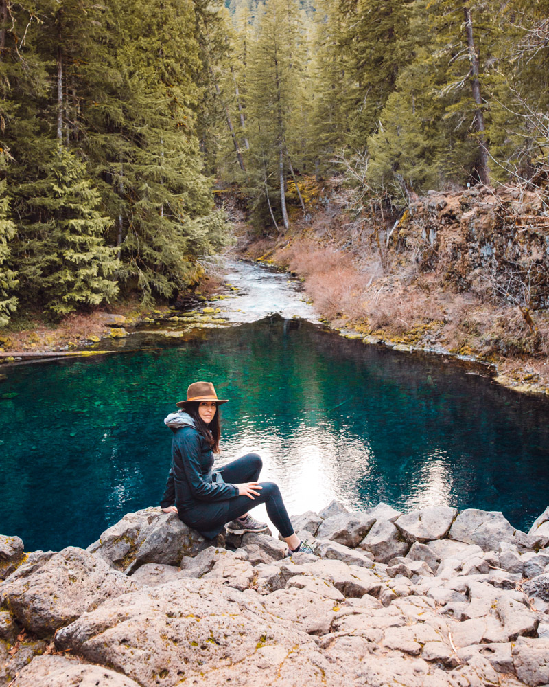
Tamolitch Falls — more commonly known as Blue Pool — is one of the most photographed spots in Oregon, and in this case, the photos aren’t exaggerating. The water really is that blue. The McKenzie River disappears underground through porous lava rock and resurfaces here, filtered and almost completely free of sediment.
The hike in follows the McKenzie River Trail through old-growth forest and is mostly flat, making it accessible to a wide range of hikers. The reveal is subtle — you walk through quiet forest, then the trees thin and the color appears below you, brighter than it seems possible.
Despite how inviting it looks, the water stays near freezing year-round (around 2°C), and submerged hazards make swimming risky. This is best approached as a scenic destination rather than a swimming hole — especially in spring when the flow is strong.
Good to know: No pass, no facilities at the trailhead. The trail can be muddy in spring. 20 minutes from Sahalie/Koosah Falls — do them together.
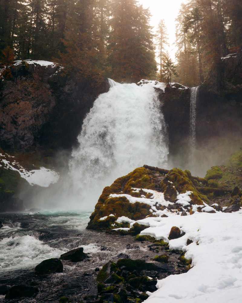
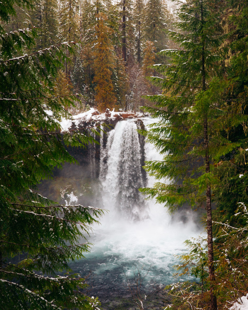
Sahalie Falls + Koosah Falls – Willamette National Forest, OR
📍 McKenzie River, OR · 2.5 mi loop · ~200 ft gain · Best: Year-round
No pass required
Sahalie and Koosah Falls sit about a mile apart along the McKenzie River, connected by a well-defined loop that follows the river through old-growth forest. You don’t have to choose between them — the trail naturally links both in one outing.
Sahalie is the more dramatic of the two — a 100-foot drop of whitewater plunging into a vivid turquoise pool. Koosah, just downstream, is wider and more layered, with a steadier, more horizontal flow. They feel different enough that seeing both doesn’t feel redundant.
The trail is moderate and steady, with the river in view for much of the hike, which keeps the scenery interesting between stops. If you’re planning a day along the McKenzie River, this loop fits easily alongside Tamolitch or Proxy without turning into an all-day commitment.
Proxy Falls – Willamette National Forest, OR
Proxy Falls — Willamette National Forest
📍 Highway 242 (McKenzie Pass), OR · 1.6 mi loop · ~164 ft gain · Best: Late June–July NW Forest Pass ($5) + free wilderness permit required June 15–Oct 15
Proxy Falls is one of the most intricate waterfalls in Oregon. The lower falls — 226 feet — spill over a moss-covered lava wall in dozens of thin, ribbon-like streams before disappearing into porous rock at the base. There’s no visible outflow, which gives the entire setting an almost suspended feeling.
The loop trail crosses sections of uneven lava field before entering forest near the falls, so sturdy footwear matters. Upper Proxy Falls is smaller but worth the short spur if you’re already there.
Access is the limiting factor. Highway 242 typically remains closed until mid-to-late June due to snow, and a free wilderness permit is required from June 15 through October 15. If the road is open, this is a high-reward stop along the McKenzie Pass corridor — but timing it correctly is key.
Bend Area
The Bend region offers quick, high-impact waterfall stops that work well as add-ons to a larger weekend. These are not long wilderness days — they’re efficient, scenic breaks between breweries, alpine lakes, or high desert trails.
Tumalo Falls is the easiest of the group, with a viewpoint just steps from the parking lot and optional longer trail extensions. (unless it is winter) Pair it with Paulina Falls at Newberry Volcanic Monument or build it into a snowshoe outing in winter.
Best for: low-effort scenic stops with flexible mileage.
Tumalo Falls
📍 Bend, OR · 0.4 mi to viewpoint (or 6+ mi loop) · Minimal gain to viewpoint · Best: Year-round NW Forest Pass ($5) or $5 day use
Tumalo Falls is a 97-foot cascade just off the road outside Bend — visible from the parking area and accessible via a short, well-maintained viewpoint trail. The effort is minimal, but the scale feels larger than expected, especially in spring when the flow is strong.
What makes Tumalo worth noting is that it doesn’t have to be a quick stop. The trail continues upstream past smaller cascades and can be extended into a 6+ mile loop through the Deschutes National Forest. Most visitors turn around at the viewpoint, which means the upper trail is noticeably quieter.
In winter, the access road closes and the approach requires snowshoes or skis from Skyliner Sno-Park, transforming it into a more involved outing. In summer, arrive early — the lot fills quickly on weekends.

Coast Range
The Coast Range waterfalls feel completely different from the Cascades — thicker forest, softer terrain, and more road-trip friendly access. Trails are generally moderate and well-maintained, making this region easy to incorporate into a coastal weekend.
Drift Creek Falls is ideally positioned between Lincoln City and Portland, making it one of the best “on the way home” stops in the state. It’s long enough to feel like a hike, short enough for kids, and dramatic enough to justify the detour.
Best for: pairing with a coast trip rather than building a full waterfall itinerary.
Drift Creek Falls
📍 Between Lincoln City and Portland, OR · 3.5 mi RT · ~400 ft gain · Best: Year-round NW Forest Pass ($5) or $5 day use
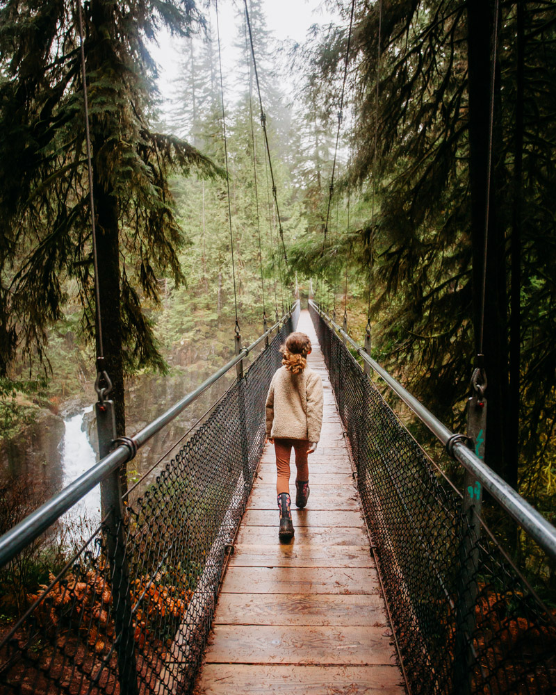
Drift Creek Falls feels different from the Cascades waterfalls on this list. Instead of basalt cliffs and volcanic amphitheaters, you’re in coastal forest — thick, damp, and densely green.
The trail is moderate and well-maintained, leading first to a 240-foot suspension bridge that spans the canyon. The bridge itself is part of the experience — slightly swaying, open to views down the gorge — before you continue to the waterfall framed below.
Because of its location between Lincoln City and Portland, Drift Creek works particularly well as a road-trip stop rather than a standalone destination. It’s long enough to feel like a hike, but accessible enough for most families, and the suspension bridge adds something memorable beyond the waterfall itself.
Mount Hood, OR
Mount Hood waterfalls require more commitment than most on this list. Trails are longer, river crossings can be seasonal, and timing matters.
Ramona Falls is best approached in late June or July once the Sandy River drops. Pair it with Tamanawas Falls if you’re spending the weekend in the area, but plan for a true half- to full-day hike.
Best for: hikers looking for a bigger day and comfortable with variable conditions.
Ramona Falls
📍 Mount Hood, OR · 7.1 mi loop · ~1,000 ft gain · Best: Late June–July NW Forest Pass ($5)
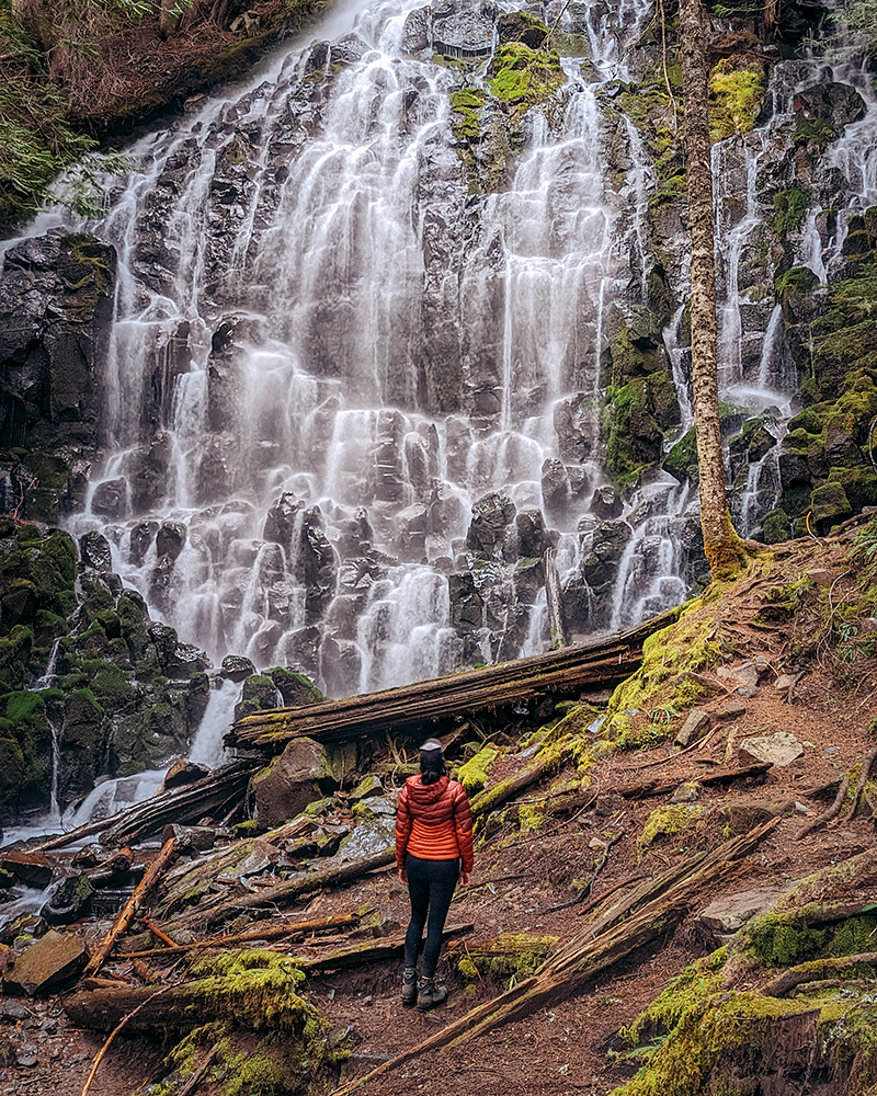
Ramona Falls is 120 feet of water fanning across a moss-covered basalt wall in thin, veil-like streams. It’s less about raw power and more about texture — dozens of narrow ribbons cascading down in a broad, intricate curtain.
The hike loops through forest on the west side of Mount Hood, with stretches along the Sandy River and occasional views of the mountain. At just over seven miles, it’s a true half-day outing rather than a quick stop.
The key consideration is the Sandy River crossing. There is no permanent bridge; hikers cross using shifting log jams that change year to year. In spring, when snowmelt is high, the crossing can be unsafe. Most hikers wait until late June or July, when water levels drop. Check recent trip reports before committing, and be prepared to turn around if conditions look unstable.
Columbia River Gorge Waterfalls
The Gorge has the densest concentration of waterfalls in the Pacific Northwest, and I have a full guide dedicated to it — covering both the Oregon and Washington sides, with crowd strategies, permit info, and day trip planning.
👉 Best Waterfall Hikes in the Columbia River Gorge (Oregon + Washington)
Highlights from that guide: Latourell Falls (my favorite short hike in the Gorge), Wahclella Falls (best payoff-to-effort ratio), Tunnel Falls on Eagle Creek (all-day adventure), plus Multnomah, Horsetail, Ponytail, Elowah, and the Washington-side gems like Panther Creek and Falls Creek Falls.
If you’re planning a Gorge trip, I also have a full planning guide: Spring in the Columbia River Gorge: Waterfalls, Wildflowers & Where to Stay.
More Waterfall + Spring Hiking
- Best Waterfall Hikes in the Columbia River Gorge — the full Gorge guide, both sides of the river
- Spring in the Columbia River Gorge: Waterfalls, Wildflowers & Where to Stay — planning a multi-day Gorge trip
- Where to Find Spring Wildflowers in Washington — pair waterfall trips with wildflower season
- 22 Best Day Hikes in Washington — year-round favorites, many with waterfalls
- 10 Epic Hikes on the Mountain Loop Highway — waterfall-heavy trails north of Seattle